Document information
Physical location:
Ferd. v. Müller, Jochmusiana B, 2, Handschriftenabteilung, Bayerische Staatsbibliothek,Munich. 72.02.02Preferred Citation:
Ferdinand von Mueller to August Jochmus von Cotignola, 1872-02-02. R.W. Home, Thomas A. Darragh, A.M. Lucas, Sara Maroske, D.M. Sinkora, J.H. Voigt and Monika Wells (eds), Correspondence of Ferdinand von Mueller, <https://vmcp.rbg.vic.gov.au/id/72-02-02>, accessed September 11, 2025
1
Published on-line at
https://www.digitale-sammlungen.de/en/view/bsb00144323?page=,1
.
2/2/72.
Gerade noch vor dem Postschluss, edler Herr Marschall, ist es mir möglich Ihnen die
Skizze eines grossen Landsees zu senden, dem ich Ihren berühmten Namen aufprägte,
u durch welchen wir stets an Ihre Anwesenheit in Australien erinnert werden. Ich habe
den ersten Geographen der Zeit, Hr Prof. Aug. von Petermann, eben auch mit dieser
Entdeckung bekannt gemacht.
Ich glaube, dass der Feldmesser Birch, sich sehr geehrt fühlen würde durch einige
anerkennende Worte u, darf ich es sagen, vielleicht ein kleines Souvenir.
Mit ehrendem Sinne u besonderer Ergebenheit der Ihre
Ferd. von Mueller
Melbourne Botanic Garden,
2 February 1872.
Just before the close of the mail, noble Marshal, I am able to send you the sketch
of a large inland lake to which I attached your famous name, and which will always
remind us of your visit to Australia.
I have also just acquainted the foremost geographer of our time, Professor August
von Petermann, with this discovery.
2
The file includes a sketch map by the surveyor Charles Weldon Birch 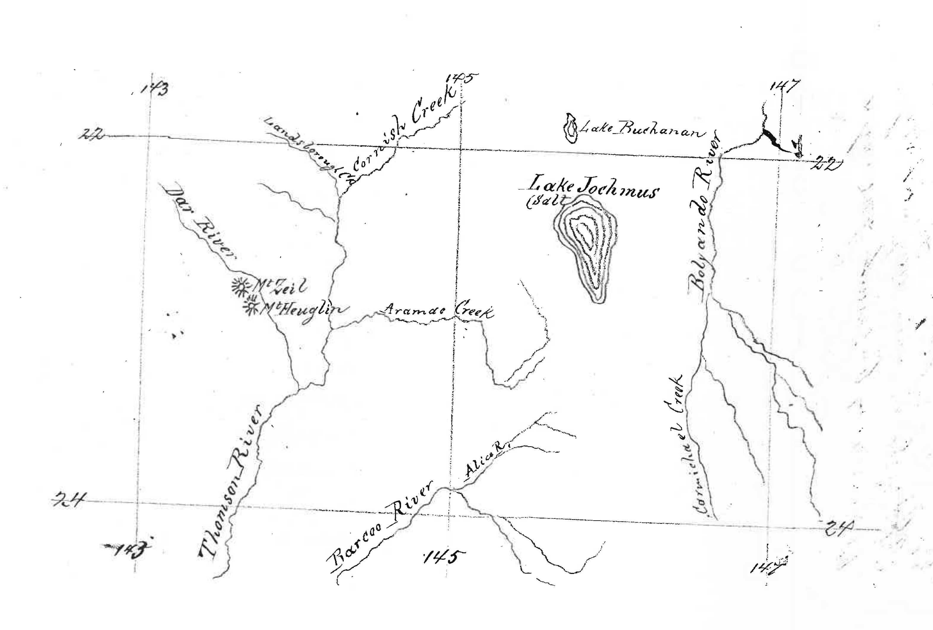
This map shows the location of the lake Birch had discovered in central Qld and named ‘Lake Jochmus’ in accordance with M's request that he name a geographical
feature in Jochmus's honour (see M to C. Birch, 10 November 1871 (in this edition
as 71-11-10a)). Also marked on the map are 'Mt Zeil' and 'Mt Heuglin', names likewise almost certainly bestowed in response to a request from M. Birch's names for all three features were included on the map, 'Süd-ost Australien', issued with
Petermann's geographische Mittheilungen, vol. 19, 1873, a digitized copy of which is available through the National Library of Australia,
http://nla.gov.au/nla.
o
bj-232433873
. However, they do not survive on modern maps; 'Lake Jochmus' is now known as Lake
Galilee, while the positions of the two 'mountains' correspond approximately to two low hills, now known as Prairie Peak and Mt Mitchell, about 25 km west of today's small town of Muttaburra, about 80 km north of Longreach.
3
Letter not found. With his letter M evidently sent Petermann Birch's account of his discovery of the lake, enabling Petermann to publish a German translation of this in
Petermann's geographische Mittheilungen, vol. 19, 1873, p. 415; see C. Birch to M, January 1872 (in this edition as 72-01-00a). M also sent a copy of Birch's sketch map to Petermann; this is now in the archive
in Gotha and was reproduced in Voigt (1996), p. 156 (where, however, it is mis-identified
as Ernest Giles's map).
I believe that surveyor Birch would feel very honoured to receive a few words of acknowledgement
and, may I add, perhaps a small souvenir.
With sentiments of respect and special devotion
Yours
Ferd. von Mueller.